Property Details
Property Description
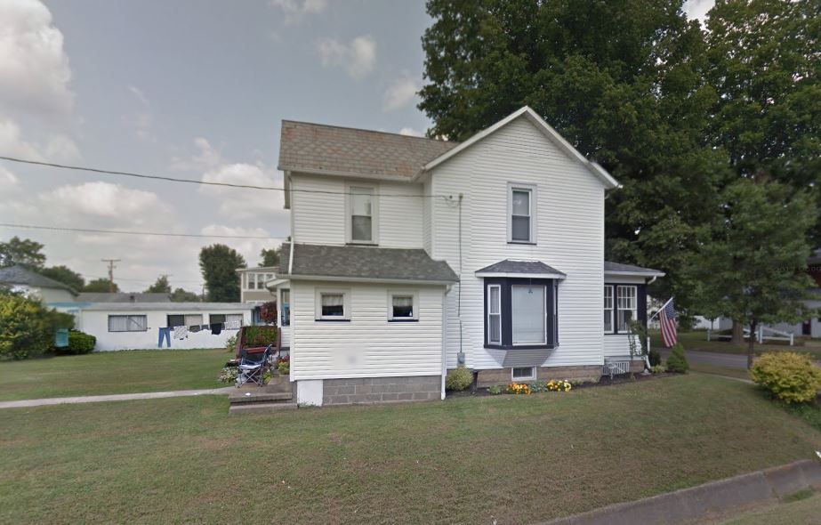
Subject property is a 0 BR / 1.00 BA Single family home w/ Car Garage containing 1,336 Sq Ft +/- built in 1930. Parcel number: 09-00012-000, 09-00013-000. Minimum Bid $ 56,666.67 . All auction end Wednesdays at 1PM. 5% buyer's premium will apply over and above high bid. Please read terms and conditions for details related to purchasing foreclosure property. Interior showings are not available. To earn a commission, Buyer referrals must be made to Auctioneer before prospective buyers make any contact with Auctioneer or register for bidding. Use link: https://www.gryphonusa.com/broker-acknowledgement-form/ This is a foreclosure situation. Property being offered by Private Selling Officer per the authorities granted in Ohio Revised Code 2329.152 . Information available has come from public sources and is believed to be accurate but is not guaranteed. Buyers should conduct their own due diligence before bidding. List Agent has not physically viewed the property. Due to the nature of the sale, interior inspections are not allowed. Cash sale only. No financing.
Legal Description
Situated in the County of Holmes in the State of Ohio, and in the Village of Killbuck and bounded and described as follows: Tract 1: Being a part of Out Lot 1 of the Village of Killbuck, Holmes County, Ohio. Described as follows: Beginning at a point on the West line of Main Street Marking the Southeast corner of Lot 156 the true point of beginning. Thence with the following Nine (9) courses: 1) S 06 degrees 04' 10" W 30.00 feet along the out lot line and along the West line of Main Street to an iron pin found; 2) N 85 degrees 23' 37" W 141.39 feet along Gary R. & Sandra Bergoon's (Deed Vol. 174, Page 569) North line and partly along Becky Croft's (Deed Vol. 276, Page 927) East line to an iron pin found; 3) N 05 degrees 57' 27" E 50.16 feet along said Croft's East line to an iron pin found; 4) N 06 degrees 20' 58" E 45.05 feet along said Croft's East line to an iron pin found on the out lot line and on the South line of Lincoln Street; 5) S 85 degrees 12' 48" E 12.00 feet along the out lot line and long the South line of Lincoln Street to an iron pin set; 6) S 06 degrees 20' 58" W 45.03 feet along Jimmy L. and Betty L. Eddy's (O.R Vol. 10, Page 111) West line to an iron pin set; 7) S 85 degrees 19' 08" E 24.48 feet along said Eddy's South line to a point on the West line of said Lot 156; 8) S 06 degrees 04' 10" W 19.98 feet along the West line of said Lot 156 to a point marking the Southwest corner of said Lot 156; 9) S 85 degrees 19' 08" E 105.00 feet along the South line of said Lot 156 to the true point of beginning. This parcel contains 0.127 acres, but subject to all highways and easements of record. The Grantor further grants unto the Grantees, his heirs and assigns, a sewer right-of-way as described in O.R. Vol. 66, Page 108. All iron pins set are 5/8 inch rebars with plastic I.D. cap marked "Baker 6938". Bearings are from Plat Vol. 14, Page 650. See Holmes County Plat Book 17, Page 791 for survey. This survey made and description prepared by Jamie D. Darr PS 7755 January 26, 2001. Tract 2: Being a part of Lot 156 of the Village of Killbuck, Holmes County, Ohio. Described as follows: Beginning at a point on the West line of Main Street Marking the Southeast corner of Lot 156 the true point of beginning. Thence with the following four (4) courses: 1) N 85 degrees 19' 08" W 105.00 feet along the lot line to point marking the Southwest corner of Lot 156; 2) N 06 degrees 04' 10" E 19.98 feet along the lot line to a point on Jimmy L. & Betty L. Eddy's (O.R. Vol. 10, Page 111) South line; 3) S 85 degrees 19' 08" E 105.00 feet along said Eddy's South line to an iron pin found on the lot line and on the West line of Main Street; 4) S 06 degrees 04' 10" W 19.98 feet along the lot line and along the West line of Main Street to the true point of beginning. This parcel contains 0.048 acres, but subject to all legal highways and easements of record. All iron pins set are 5/8 rebars with a plastic I.D. cap marked " Baker 6938". Bearings are from Plat Vol 14, Page 650. See Holmes County Plat Book 17, Page 791 for survey. This survey made and description prepared by Jamie D. Darr Ps 7755 January 26, 2001.
Location
Foreclosure Details
Click the link to review the Conditions of Sale for this auction.
Conditions of SaleAuction By
