Property Details
Property Description
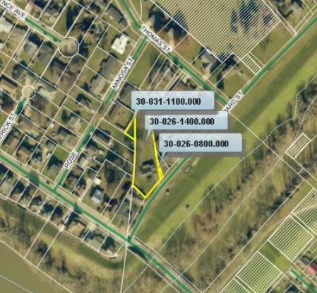
Subject property is a 3 BR / 1.50 BA Single Family Home w/ 1 Car Garage, containing 1,644 Sq Ft +/- built in 1956. Parcel number: 30-026-1400.000, 30-026-0800.000, 30-031-1100.000. Minimum Bid $ 58,133.33 . All auction end Wednesdays at 1PM. 5% buyer's premium will apply over and above high bid. Please read terms and conditions for details related to purchasing foreclosure property. Interior showings are not available. To earn a commission, Buyer referrals must be made to Auctioneer before prospective buyers make any contact with Auctioneer or register for bidding. Use link: https://www.gryphonusa.com/broker-acknowledgement-form/ This is a foreclosure situation. Property being offered by Private Selling Officer per the authorities granted in Ohio Revised Code 2329.152 . Information available has come from public sources and is believed to be accurate but is not guaranteed. Buyers should conduct their own due diligence before bidding. List Agent has not physically viewed the property. Due to the nature of the sale, interior inspections are not allowed. Cash sale only. No financing.
Legal Description
Situated in the City of Ironton, Section 17 and Section 18, T-1-N, R-18-W, Lawrence County, Ohio. Being the tract recorded in Book 690 at Page 295 of the Official Records of the Lawrence County Recorder?s Office. Being Parcel Numbers 30-026-1400.000, 30-026-0800.000, 30-031-1100.000 and being more fully described as follows: Beginning for reference at an Iron Pin Found (1-inch rebar, no cap, good condition) at the Northwest corner of Lot 4 of the James F. Laber Addition, Plat Book 5, Page 253. Thence with the East Right-of-Way line of Mimosa Street (40-feet wide), S 31?- 36?- 25? W ? 82.89 feet to a point on the West line of Section 17. Thence leaving the Right-of-Way of said road and with the West line of Section 17, S 03?- 00?- 15? W ? 216.97 feet to an Iron Pin set this survey, from which an Iron Pin Found (?-inch rebar, no cap, good condition) bears, S 72?- 06?- 33? W ? 4.01 feet. Said Iron Pin set is the Principal Place of Beginning for this survey. Thence leaving the West line of Section 17 and with the South line of Greg F. Rodmann (O.R. 324 Pg. 419), N 31?- 39?- 32? E ? 78.82 feet to an Iron Pin set this survey. Thence leaving the South line of Rodmann and with the West line of Phyllis Carrico (O.R. 669 Pg. 371), Timothy M. Parnell (Vol. 556 Pg. 536), Kenneth Carpenter (Vol. 401 Pg. 540) the following courses; S 09?- 47?- 41? E ? 262.41 feet to an Iron Pin set this survey, passing an Axle Found at 61.53 feet, and passing an Iron Pin Found (?-inch rebar, no cap, good condition) at 90.92 feet; S 19?- 43?- 50? E ? 68.23 feet to an Iron Pin set this survey; Thence leaving the West line of Carpenter and with the North line of Orchard Street, S 41?- 54?- 38? W ? 107.00 feet to a point, passing an Iron Pin set this survey at 15.00 feet. Thence leaving the North line of Orchard Street and with the North line of Gerald W. Sherer (O.R. 362 Pg. 678), N 47?- 46?- 46? W ? 71.11 feet to an Iron Pipe Found (1-inch hollow pipe, no tag, good condition), passing an Iron Pin set this survey at 1.26 feet. Thence leaving the North line of Sherer and with the lines of Eileen Unger (Vol. 420 Pg. 427) and Brittany A. Thompson (O.R. 70 Pg. 167, O.R. 320 Pg. 786) the following courses; N 03?- 00?- 14? E ? 179.69 feet to an Iron Pipe Found (1-inch hollow, no tag, good condition), passing an Iron Pin Found (1-inch rebar, no cap, good condition) at 27.68 feet; N 56?- 13?- 59? W ? 49.00 feet to an Iron Pipe Found (3-inch solid pipe, no tag, good condition); Thence leaving the lines of Thompson and with the East line of Rachel E. Kingery (Vol. 612 Pg. 30), N 29?- 50?- 52? E ? 93.25 feet to an Iron Pin set this survey. Said Iron Pin set is the Principal Place of Beginning for this survey. Said survey contains 0.714 Acres (31094.1 Sq. Feet), more or less. The attached plat, File Name 20062 is made a part of this description. All Iron Pins set this survey and on previous surveys are ?-inch x 30-inch rebar and have a plastic cap on them stamped Dale Exline P.S. 6722. Basis of Bearings is State Plane Grid North, NAD83(2011) Ohio South Zone. Tied by GPS to ODOT CORS Stations. To denote angles only. Subject to all legal easements and Right-of-Ways not listed above. This description was prepared from an actual survey performed by me, Dale A. Exline, or under my direct supervision from June 3, 2020 ? June 15, 2020.
Location
Foreclosure Details
Click the link to review the Conditions of Sale for this auction.
Conditions of SaleAuction By
