Property Details
Property Description
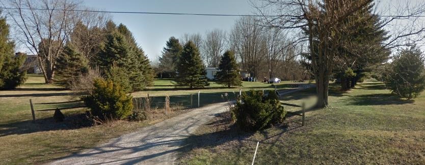
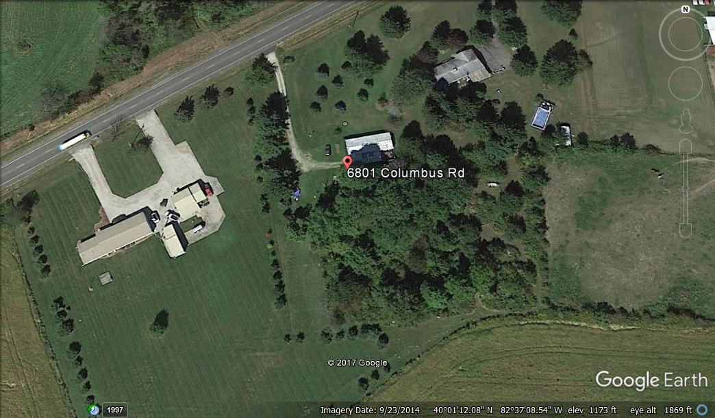
6801 Columbus Rd, Granville, OH is a single family manufactured home that contains 3br/2ba and 1,440 sq ft and was built in 1980. It contains 3 bedrooms and 2 bathrooms with a lot size of 2.08 acres +/-. Information not guaranteed. PSO has not been granted acess to the property.
Legal Description
Parcel No .1: Situated in the State of Ohio, County of Licking, Township of Harrison, being located in Lots 39 and 40 of Section 1, Township 1, Range 14, United States Military Lands and being part of those tracts of land conveyed to Roger and Sally M. Yost, by deed of record in Deed Book 697, Page 422 and Deed Book 699, Page 21, all references being to records in the Recorder's Office, Licking County, Ohio and bounded and described as follows: Beginning at a point in the centerline of State Route 16, at the Northwesterly corner of the Roger and Sally M. Yost 3.483 acre tract (Deed Book 697, Page 422), the Northeasterly corner of the 1.372 acre tract conveyed to Frank E. Young, by deed of record in Official Record 21, Page 975, said point also being located South 52° 32' 52" West, 66.97 feet and South 55° 32' 52" West, 229.83 feet from the intersection of said centerline of State Route 16 with the Northerly line of Lot 39, the Southerly line of Lot 29 of Section 1; Thence North 55° 32' 52" East, along said centerline of State Route 16, a distance of 137.66 feet to a point; thence South 29° 06' 56" East, a distance of 320.65 feet to a point; thence South 9° 17' 15" East, a distance of 200.00 feet to a point in the Northerly line of the Richard W. and Alice V. Atkins tract, of record in Deed Book 803, Page 729; thence South 80° 42' 45" West, along said Northerly line of the Richard W. and Alice V. Atkins tract, a distance of 283.39 feet to the Southwesterly corner of the Frank E. Young 1.372 acre tract; thence North 52° 32' 52" East, along the Southerly line of said Frank E. Young 1.372 acre tract, a distance of 96.50 feet to the Southeasterly corner of said tract; thence North 14° 19' 30" West, along the Easterly line of said 1.372 acre tract, a distance of 399.10 feet to the place of beginning, containing 2.075 acres, more or less. Subject, however, to all legal rights-of-ways and/or easements, if any, of previous record. Bearings contained herein are based on the same meridian as bearings in deed of record in Deed Book 397, Page 422. Thomas D. Sibbalds, Registered Surveyor No. 5908. Excepting Therefrom: Situated in the State of Ohio, County of Licking, Township of Harrison and being a part of Lot 40 located in the 1st Quarter of Township 1, Range 14, United States Military lands and being 0.046 acre of that 2.075 acre tract as conveyed to William M. Barker and Kimberly A. Barker by deed of record in Official Record Volume 570, Page 484, all references being to those of record in the Recorder's Office. Licking County, Ohio and being more particularly bounded and described as follows: Beginning at an existing iron pin marking the Southwesterly most corner of said 2.075 acre tract, said iron pin also marking the Southwesterly corner of that 1.372 acre tract as conveyed to Scott D. Young by deed of record in Official Record Volume 681, Page 646; thence North 53° 42' 21" East, along the Southerly line of said Young 1.372 acre tract and the Northerly line of said Barker 2.075 acre tract, a distance of 96.31 feet to an existing iron pin marking the Southeasterly corner of said Young 1.372 acre tract; thence South 13° 16' 10" East, across said Barker 2.075 acre tract, a distance of 45.61 feet to an iron pin set in the Southerly line of said Barker tract and also being the Northerly line of the 2.250 acre tract as conveyed to Scott D. Young and Valerie L. Young by deed of record in Instrument #199807240028081; thence South 81° 50' 55" West, along the Southerly line of said Barker tract and a Northerly line of said Young 2.250 acre tract, a distance of 89.00 feet to the point of beginning. Containing 0.046 acre, more or less, according to a survey made by Ball Surveying, during, April, 2001. Subject to any and all easements, rights of way, conditions and restrictions of record, all legal highways, zoning ordinances, rules and regulations. The bearings in the above description are based upon the Southerly line of said Scott & Valerie Young 1.250 acre tract as being South 81° 50' 55" West. All iron pins set are 5/8" X 30" with yellow plastic I.D. Caps stamped Ball P.S. #6878. The grantees, their heirs and assigns, do hereby acknowledge and agree that this conveyance is subject to the covenant and agreement of the grantees, their heirs and assigns, that this lot does not constitute a building site and that no building shall be constructed on said premises without the, prior written approval of the Licking County Planning Commission. Leaving a total of 2.029 acres remaining. Parcel No. 2: Situated in the State of Ohio, County of Licking, Township of Harrison and being a part of Lot 40 and Lot 39 located in the 1st Quarter of Township 1, Range 14, United States Military Lands and being 0.046 acre of that 2.250 acre tract as conveyed to Scott D. Young and Valerie L. Young by deed of record in Instrument #199807240028081, all references being to those of record in the Recorder's Office, Licking County, Ohio, said 0.046 acre being more particularly bounded and described as follows: Beginning at an existing iron pin marking the Southeasterly most corner of said 2.250 acre tract, said iron pin also marking the Southeasterly corner of that 2.075 acre tract as conveyed to William M. & Kimberly A. Barker by deed of record in Official Record 570, Page 484; thence South 51° 56' 33" West, along the Southerly line of said Young 2.250 acre tract, a distance of 83.50 feet to an iron pin set; thence North 38° 03' 27" West, across said Barker, 2.250 acre tract, a distance of 48.03 feet to an iron pin set in a Northerly line of said 2.25 acre tract and in a Southerly line of said Barker 2.075 acre tract; thence North 81° 50' 55" East, along the Southerly line of said Barker tract and a Northerly line of said Young, 2.250 acre tract, a distance of 96.33 feet to the point of beginning. Containing 0.046 acre, more or less, according to a survey made by Ball Surveying, during April, 2001. Subject to any and all easements, rights of way, conditions and restrictions of record, all legal highways, zoning ordinances, rules and regulations. Basis of bearings: the bearings in the above description are based upon the Northerly line of said Scott & Valerie Young 2.250 acre tract as being North 81° 50' 55" East. All iron pins set are steel rebar, 5/8" X 30" with yellow plastic I.D. Caps stamped Ball P.S. 06878. The grantees, their heirs and assigns, do hereby acknowledge and agree that this conveyance is subject to the covenant and agreement of the grantees, their heirs and assigns that this lot does not constitute a building site and that no building shall be constructed on said premises without the prior written approval of the Licking County Planning Commission. Excepting conditions, easements, restrictions, rights of way and zoning and other governmental regulations of record and taxes and assessments not yet due and payable which Grantees assume and agree to pay as a part of the consideration herein.
Location
Foreclosure Details
Click the link to review the Conditions of Sale for this auction.
Conditions of SaleAuction By
