Property Details
Property Description
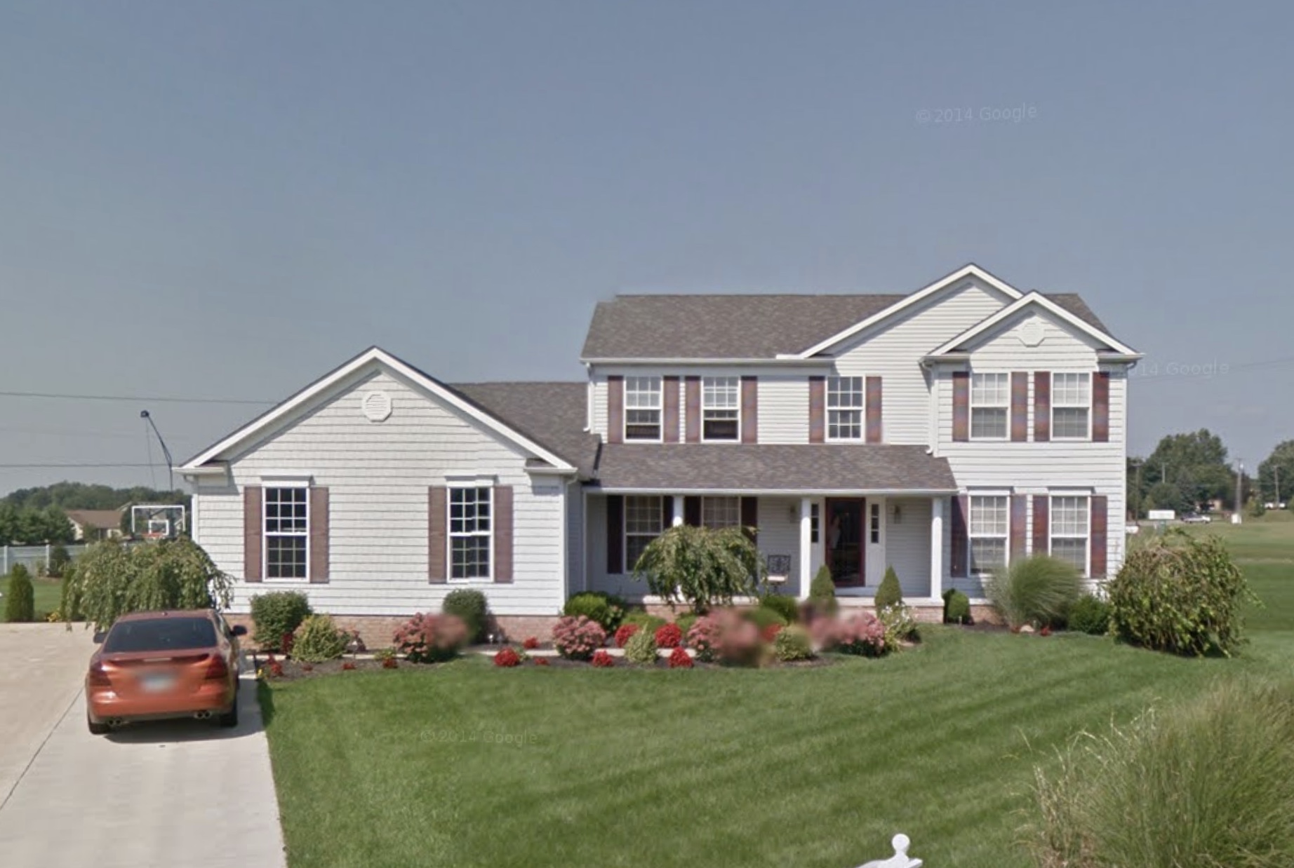
Subject property is a 5 BR / 3.00 BA Single Family Home w/ 1 Car Garage, containing 2,752 Sq Ft +/- built in 2005. Parcel number: 10008084. Minimum Bid $ 244,000.00 . All auction end Wednesdays at 1PM. 5% buyer's premium will apply over and above high bid. Please read terms and conditions for details related to purchasing foreclosure property. Interior showings are not available. Buyer Agents, please refer to the Buyer Agent Agreement between your brokerage and buyer client for any auction with a Buyers Premium under 6%. For sales with Buyer Premium over 6%, Buyer referrals must be made to Auctioneer before prospective buyers make any contact with Auctioneer or register for bidding. Use link: https://www.gryphonusa.com/broker-acknowledgement-form/ This is a foreclosure situation. Property being offered by Private Selling Officer per the authorities granted in Ohio Revised Code 2329.152 . Information available has come from public sources and is believed to be accurate but is not guaranteed. Buyers should conduct their own due diligence before bidding. List Agent has not physically viewed the property. Due to the nature of the sale, interior inspections are not allowed. Cash sale only. The auction is subject to postponement and cancellation. No financing.
Legal Description
Situated in the Township of Plain, County of Stark and State of Ohio: Known as and being Lot Number 36 in Stonehedge Development No. 2, as set forth in Plat Book Volume 63, Page 140-141, of the Stark County, Ohio, Records. Excepting Therefrom: Situated in the County of Stark, Plain Township and located in the SW Quarter of Section 10, T11, R8 of the Congress Lands, and being part of Lot No. 36 in Stonehedge Development No. 2, as shown in Plat Book 63, Page 140-141 of the Stark County Records, and being part of a parcel of land, now or formerly owned by Todd E. Brown and Jessica L. Brown per Instrument Number 200508150053936 of the Stark County Records, and being more fully described as follows: Being a parcel of land located on the right side of the centerline of State Route 43 per a centerline plat made by URS Corporation for the Ohio Department of Transportation and recorded as Image Number of the Stark County Recorder records. Beginning at a found 3” diameter brass disc in concrete found in a monument box (PLA 046) stamped “Stark County Engineer Section Corner T11 N, R8W S9 S10 046 2002” at the NW corner of the SW quarter of Section 10, said pin being on the existing centerline of right of way of State Route 43 (aka North Market Ave.) at Station 1037+88.03; 1). Thence S 00 deg. 43 min. 10 sec. W, 817.46 feet, along the west line of Section 10, and the existing centerline of right of way of State Route 43, to a point on the existing centerline of State Route 43 and also the southwest corner of a parcel of land, now or formerly owned by CDF Holdings, LLC per Instrument Number 201212310060047 of the Stark County Record, said point being a State Route 43 centerline of right of way Station 1029+70.57; 2). Thence S 88 deg. 23 min. 17 sec. E, 40.01 feet, along the aforementioned CDF Holdings, LLC, to a point at the Grantor’s northwest corner, said point being on the existing east right of way line of State Route 43 and on the southerly line of the aforementioned CDF Holdings, LLC, parcel, said point and being located 40.00 feet right of State Route 43 centerline of right of way Station 1029+69.95, and being the true point of beginning, for the following parcel herein described; 3). Thence S 88 deg. 23 min. 17 sec. E, 5.00 feet, along the existing north line of Grantor’s parcel, and the existing south line of the aforementioned CDF Holdings, LLC parcel to a rebar set at a point on the proposed east right of way line of State Route 43, said point being the proposed northwest corner of Grantor’s parcel, said point being located 45.00 feet right of State Route 43 centerline of right of way Station 1029+69.87; 4). Thence S 00 deg. 43 min. 10 sec. W, 62.37 feet, along the proposed east right of way line of State Route 43, and the proposed west line of the Grantor’s parcel, to a rebar set at a point on the proposed east right of way line of State Route 43, said point being the proposed southwest corner of Grantor’s parcel, said point also being located on the north of a parcel of land, now or formerly owned by Johnie Lewis and Geneva Lewis per Instrument Number 200305210047198 of Stark County Records, said point being located 45.00 feet right of State Route 43 centerline of right of way Station 1029+07.50; 5). Thence N 63 deg. 11 min. 15 sec. W, 5.57 feet, along the existing south line of Grantor’s parcel and the existing north line of aforementioned Johnnie Lewis and Geneva Lewis parcel, to a point on the existing east right of way line of State Route 43, said point being the existing southwest corner of Grantor’s parcel, said point also being the existing northwest corner of the aforementioned Johnie Lewis and Geneva Lewis parcel, said point being located 40.00 feet right of State Route 43 centerline of right of way Station 1029+09.95; 6). Thence N 00 deg. 43 min. 10 sec. E, 60.00 feet, along the existing east right of way line of State Route 43, and the existing west line of Grantor’s parcel, to the point of beginning and containing 0.007 acres of land, more or less, of which 0.000 acres is present road occupied. The above area is part of Auditor's Parcel No. 5218088. The basis of bearing for this description is based on the Ohio State Plane Coordinate System, North Zone, NAD83 (86ADJ). All rebars set are ¾” diameter x 30” long with a 2” diameter aluminum cap stamped “ODOT RW – URS Corporation 7122”. This description was prepared and reviewed by, or under the direct supervision of, Dan Stankavich, P.S. Number 7122, on November 12, 2013 for the Ohio Department of Transportation and URS Corporation and is based on a survey by, or under the direct supervision of David P. Povich, P.S. 7773, in January of 2012.
Location
Foreclosure Details
Click the link to review the Conditions of Sale for this auction.
Conditions of SaleAuction By
