Property Details
Property Description
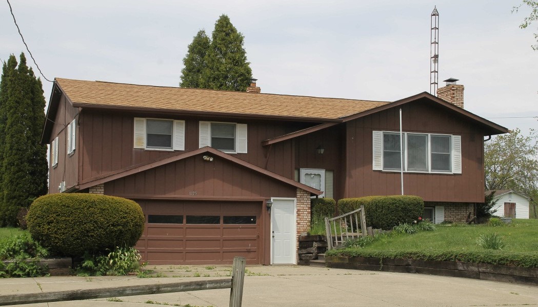
Investment Opportunity or Owner User you don't want to miss this opportunity. 3 BR / 1 BA home containing 1692 Sq Ft +/- built in 1977 . Appraised $75,000. Property must sell for 2/3 of appraised value. --- Online Only Offering. 5% buyers premium will apply over and above high bid. Please read terms and conditions for details related to purchasing foreclosure property. Brokers welcome. Contact PSO for broker registration and co-op info. Interior showings are not available.*** Info available has come from public sources. Auctioneer has not been granted access to the property.
Legal Description
Parcel One: Situated in the Township of Washington, County of Richland and State of Ohio and being part of the Southwest Quarter of Section 12, Township 20, Range 18, and described as follows: Beginning at a point in the centerline of Hanley Road (C.H. 139), 547 feet from the Southwest corner of said Quarter Section as measured along said centerline; thence east along said centerline and the South line of said Quarter Section 110 feet; thence North parallel to the West line of said Quarter Section 230 feet; thence West parallel to the South line of said Quarter Section 110 feet; thence South 230 feet to the place of beginning, containing 0.581 acres more or less but subject to all legal highways. Parcel Two Situated in the County of Richland in the State of Ohio in the Township of Washington: and being a part of the Southwest Quarter of Section 12, Township 20 North, Range 18 West, more particularly described as follows: Commencing at a PK spike found and accepted as marking the southwest corner of said quarter: Thence, North 90 degrees 00 minutes 00 seconds East with the south line of said quarter, the same being the centerline of Hanley Road (County Highway 139), a distance of 657.75 feet to a PK spike set marking the southeast corner of a 0.581 of an acre parcel currently owned by Furner (deed reference: Volume 911, page 169), the place of beginning of the parcel herein described; Thence, North 3 degrees 17 minutes 00 seconds East with Furner's east line, passing through an iron pin found at 20.00 feet, a total distance of 230.00 feet to an iron pin found marking Furner's northeast corner; Thence, North 90 degrees 00 minutes 00 seconds East a distance of 60.00 feet to an iron pin found marking the northwest corner of a 0.581 of an acre parcel currently owned by Stollings (deed reference: Volume 666, page 190); Thence, South 3 degrees 17 minutes 00 seconds West with Stollings southwest west line, passing through an iron pin found at 210.00 feet, a total distance of 230.00 feet to a PK spike set on said south line and said centerline, said spike marking Stollings southwest corner; Thence, South 90 degrees 00 minutes 00 seconds West with said south line and said centerline a distance of 60.00 feet to the place of beginning, containing 0.317 of an acre, according to survey by Douglas C. Seller, Professional Surveyor #6869 on September 18, 1992, but subject to the right of way of Hanley Road. Bearings are based on an assumed meridian and are intended to be used for angular determination only. The grantee, his heirs and assigns do hereby covenant and agree that the parcel of land described by this instrument will not be conveyed by said grantee, heirs or assigns independently from a contiguous parcel of land without the approval of the City of Mansfield Planning Commission. Save and except the following: (Exception from Parcel Two) Situated in the Township of Washington, County of Richland, State of Ohio and being part of the Southwest Quarter of Section 12, Township 20, Range 18 and being more particularly described as follows: Commencing at a brass top monument found in the southwest corner of said Southwest Quarter, said monument also being in the intersection of the centerline of Little Washington Road (C.H. 301) and the centerline of Hanley Road (C.H. 139); Thence S 89? 37' 26" E, 708.27 feet along the south line of said Southwest Quarter to a point, said point being the true place of beginning; Thence with the following four courses: 1) N 03? 50' 42" E, 224.36 feet to an iron pin set in the south line of a parcel of land conveyed to Nancy J. Arnold by official records volume 2085, page 205 and passing through an iron pin set at 14.27 feet; 2) S 89? 24' 33" E, 10.00 feet along said south line of said land of Nancy J. Arnold to an iron pin found in the northwest corner of a parcel of land conveyed to Scott A. Secrist by official records volume 896, page 624; 3) S 03? 50' 42" W, 224.33 feet along the west line of said land of Scott A. Secrist to a point being in said south line of said Southwest Quarter and passing through an iron pin found at 210.54 feet; 4) N 89? 37' 26" W, 10.00 feet along said south line of said Southwest Quarter to the true place of beginning, and containing 0.051 acre, more or less, and subject to all legal highways and easements of record. Grantees, their heirs and assigns do hereby covenant and agree that the parcel of land described in this instrument or any portion thereof does not constitute a principal building site under applicable zoning. Bearings are to an assumed meridian and are used to express angles only. According to a survey made in July 2012 by Roger L. Stevens, Ohio Registered Surveyor No. 7052. All iron pins set are 5/8" diameter rod with plastic cap stamped "Stevens 7052". Containing after said exception, 0.266 acres of land, more or less.
Location
Foreclosure Details
Click the link to review the Conditions of Sale for this auction.
Conditions of SaleAuction By
