Property Details
Property Description
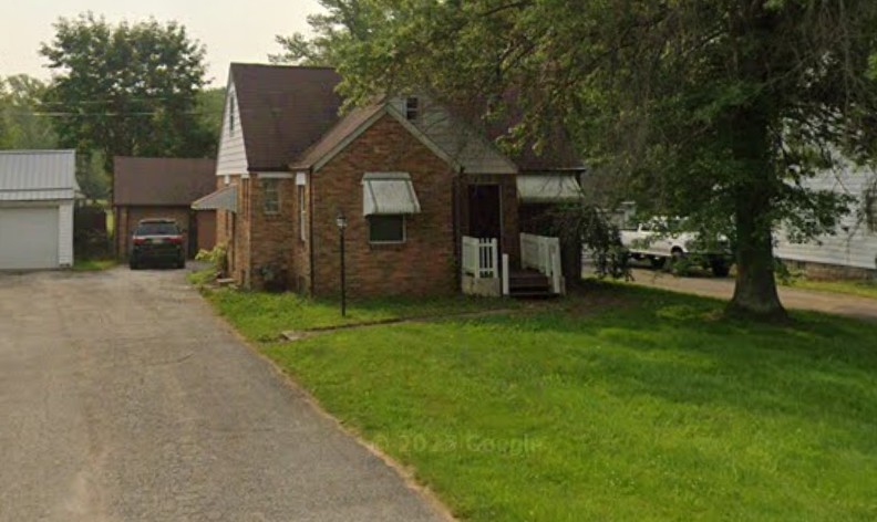
Subject property is a 3 BR / 1.00 BA Single Family Home w/ 2 Car Garage, containing 1,772 Sq Ft +/- built in 1942. Parcel number: 040254000500. Minimum Bid $ 66,000.00 . All auction end Wednesdays at 1PM. 5% buyer's premium will apply over and above high bid. Please read terms and conditions for details related to purchasing foreclosure property. Interior showings are not available. To earn a commission, Buyer referrals must be made to Auctioneer before prospective buyers make any contact with Auctioneer or register for bidding. Use link: https://www.gryphonusa.com/broker-acknowledgement-form/ This is a foreclosure situation. Property being offered by Private Selling Officer per the authorities granted in Ohio Revised Code 2329.152 . Information available has come from public sources and is believed to be accurate but is not guaranteed. Buyers should conduct their own due diligence before bidding. List Agent has not physically viewed the property. Due to the nature of the sale, interior inspections are not allowed. Cash sale only. The auction is subject to postponement and cancellation. No financing.
Legal Description
Situated in the County of Ashtabula, State of Ohio, and is described as follows: All that certain lands situate in Lot 17, Township of Ashtabula, Township Number 12 North, Range III West, in the Connecticut Western Reserve Survey, County of Ashtabula, State of Ohio, a resurvey of the lands to CitiFinancial, Inc., as recorded in Deed Volume 498, Page 1988 (PPN 04-025-40-005-00) in the Office of the County Recorder, further described: Beginning at a point to mark the East line of Austinburg Road (66 feet wide) at the Southwest corner of lands to N. H. Limpert, as recorded in Deed Volume 353, Page 511 (said point being referenced by a 3/4" iron pipe found South 74 degrees 09' 49" East, 0.38 feet from the corner) said point being located from a 3/4" iron pipe found to mark the right of way intersection of the East line of Austinburg Road with the South line of West 58th Street (50 feet wide) South 14 degrees 20' 51" West, with the East line of Austinburg Road, a distance of 87.89 feet to a 5/8" iron pin found to mark an angle point in the East line of Austinburg Road and South 11 degrees 25' 25" West, with the East line of Austinburg Road, a distance of 107.12 feet to the point and place of beginning. Thence; the following (6) courses and distances: South 78 degrees 34' 35" East, with the South line of said Limpert, a distance of 243.34 feet to a capped 5/8" iron pin set to mark a point at the Southeast corner of said Limpert, in the West line of lands to C. & A. J., Jr. Simrak, as recorded in Deed Volume 234, Page 1964. Thence; South 11 degrees 28' 21" West, with the West line of said Simrak, a distance of 43.40 feet to mark a point in the West line of said Simrak and at the Northeast corner of lands to J. C. Strubbe, as recorded in Deed Volume 483, Page 1048 (said point being referenced by a 5/8" iron pipe found South 23 degrees 36' 33" East, 0.56 feet from the corner). Thence; North 80 degrees 07' 20" West, with the North line of said Strubbe, a distance of 143.39 feet to a 5/8" iron pipe found to mark an angle point in the North line of said Strubbe. Thence; South 11 degrees 27' 00" West, with the North line of said Strubbe, a distance of 3.00 feet to a 5/8" iron pipe found to mark an angle point in the North line of said Strubbe. Thence; North 83 degrees 00' 00" West, with the North line of said Strubbe, a distance of 100.26 feet to a p. k. nail found inside a 3/4" iron pipe to mark a point at the Northwest corner of said Strubbe and in the East line of Austinburg Road. Thence; North 11 degrees 25' 25" East, with the East line of Austinburg Road, a distance of 58.00 feet to the point and place of beginning, said land containing 0.2734 acres, but subject to all highways and easements, as surveyed and described in November 2011, as illustrated on a certain map recorded in the Office of the Ashtabula County Engineer, by Timothy E. Stocker, P. S. 7245 Crabbs' Surveying Order 5260. Basis of bearings are to an assumed meridian along the centerline of Austinburg Road, North 11 degrees 25' 25" East. All iron pins set are 5/8" X 30" rebar with cap "Crabbs 7245".
Location
Foreclosure Details
Click the link to review the Conditions of Sale for this auction.
Conditions of SaleAuction By
