Property Details
Property Description
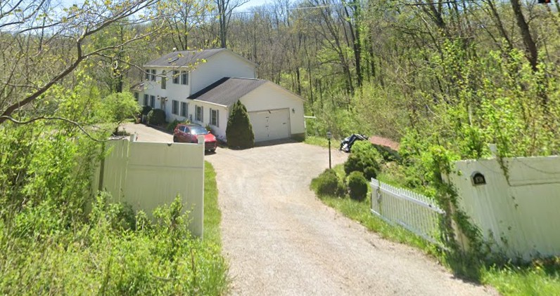
Subject property is a 3 BR / 2.00 BA Single Family Home w/ 2 Car Garage, containing 2,912 Sq Ft +/- built in 2000. Parcel number: 06-90-26-19-007. Minimum Bid $ 200,000.00 . All auction end Wednesdays at 1PM. 5% buyer's premium will apply over and above high bid. Please read terms and conditions for details related to purchasing foreclosure property. Interior showings are not available. To earn a commission, Buyer referrals must be made to Auctioneer before prospective buyers make any contact with Auctioneer or register for bidding. Use link: https://www.gryphonusa.com/broker-acknowledgement-form/ This is a foreclosure situation. Property being offered by Private Selling Officer per the authorities granted in Ohio Revised Code 2329.152 . Information available has come from public sources and is believed to be accurate but is not guaranteed. Buyers should conduct their own due diligence before bidding. List Agent has not physically viewed the property. Due to the nature of the sale, interior inspections are not allowed. Cash sale only. The auction is subject to postponement and cancellation. No financing.
Legal Description
The following described premises, situated in the Township of Blue Rock, County of Muskingum and State of Ohio: TRACT #9 Being 5.00 acres, more or less, part of Parcel 06-90-26-19, in the southeast Quarter of Section 26 in the fourth Quarter of Township 12 north, Range 12 west, Congress Lands East of the Scioto River, in the Township of Blue Rock, in the County of Muskingum, in the State of Ohio, and more particularly described as follows: Commencing at the southeast corner of Section 26; thence, along the Section line, N 06° 03' 25" E 1185.35' to a 5/8" steel pin set; thence, through the property of Robert D. White, 1070-337, the following 6 courses: 1. Thence, N 82° 52' 09" W 443.70' to a 5/8" steel pin set; 2. Thence, continuing N 82° 52' 09" W 487.73' to a 5/8" steel pin set; 3. Thence, N 82° 52' 09" W 112.05' to a #5 rebar found; 4. Thence, N 07° 08' 51" E 388.39' to a #5 rebar found; 5. Thence, N 75° 21' 12" W 53.08' to a 5/8" steel pin set; 6. Thence, continuing N 75° 21' 12" W 270.22' to a 5/8" steel pin set, said 5/8" steel pin set being the TRUE POINT OF BEGINNING; thence, continuing through the property of Robert D. White, 1070-337, the following 3 courses: 1. Thence, continuing N 75° 21' 12" W 281.24' to a 5/8" steel pin set; 2. Thence, N 07° 08' 51" E 665.37' to a 5/8" steel pin set; 3. Thence, continuing N 07° 08' 51" E 30.00' to a point in Rural Dale Road, CR 31; thence, along the centerline of Rural Dale Road, CR 31, the following 4 courses: 1. Thence, N 52° 27' 36" E 18.77' to a point; 2. Thence, N 64° 20' 07" E 64.07' to a point; 3. Thence, N 79° 43' 58" E 168.90' to a point; 4. Thence, N 84° 21' 29" E 51.77' to a point; thence, through the property of Robert D. White, 1070-337, the following 2 courses: 1. Thence S 07° 08' 51" W 15.00' to a 5/8" steel pin set; 2. Thence, continuing S 07° 08' 51" W 827.00' to the TRUE POINT OF BEGINNING, containing 5.00 acres, more or less, including public road right-of-way and is subject to all easements, rights-of-way, or restrictions, whether recorded or implied. Bearings are based on a survey by R.L. Daniels of 50.00 acres, S 07° 08' 51" W and are for angular calculations only. All 5/8" steel pins set are 30" long with plastic cap marked "E.R.D. 7142".
Location
Foreclosure Details
Click the link to review the Conditions of Sale for this auction.
Conditions of SaleAuction By
