Property Details
Property Description
3BR / 1 BA Single Family Home w/ containing 1,960 Sq Ft +/- built in 1912. Appraised $ 135,000.00 2/3 Min bid $ 90000.00. Property must sell for 2/3 of appraised value. --- Online Only Offering with bids ending mid-day. See auction details for exact time. 5% buyers premium will apply over and above high bid. Please read terms and conditions for details related to purchasing foreclosure property. Interior showings are not available. *** Info available has come from public sources. Auctioneer has not been granted access to the to the property.
Legal Description
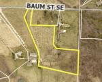
Situated in the Township of Canton, County of Stark and State of Ohio and known as being part of the Northwest quarter of section 35, (T-10, R-8), and is part of a 51.381 acre tract of land conveyed to John J. Blend, Trustee by a deed recorded in Imaging Number 2000005055 of the Stark County Records, more fully bounded and described as follows, to-wit; Beginning at a Standard County disc (Can 134) in Monument Box found at the Northeast corner of said Northwest Quarter of Section 35, Thence S 01? 37' 23" W along the East line of said quarter Section, said line also being the East line of a tract of land now or formerly owned by D. & D. Rusnak (1997040591), a distance of 559.96 feet to a 5/8 inch iron bar with Hinton cap found at the Southeast corner of said Rusnak tract, said iron bar being the true place of beginning for the tract of land herein described; 1. Thence continuing S 01? 37' 23" W along the East line of said quarter section, a distance of 340.74 feet to a 5/8 inch iron bar with Conery cap set at a new point; 2. Thence N 77? 02' 05" W along a new split line, a distance of 553.18 feet to a 5/8 inch iron bar with Conery cap set at a new point; 3. Thence N 04? 35' 43" E along a new split line, a distance of 124.80 feet to a 5/8 inch iron bar with Conery cap set at a new point; 4. Thence N 09? 46' 21" W along a new split line, a distance of 58.44 feet to a 5/8 inch iron bar with Conery cap set at a new point; 5. Thence N 22? 17' 20" W along a new split line, a distance of 522.06 feet to a 5/8 inch iron bar with Conery cap set at a new point; 6. Thence N 23? 31' 00" E along a new split line, a distance of 140.31 feet to a mag nail set at a new point on the centerline of Baum Street S.E., a 60 foot public right-of-way, as per Stark County Road Record A, Page 224, passing over a 5/8 inch iron bar with Conery cap set at 107.93 feet; 7. Thence S 88? 35' 02" E along said centerline, said line also being the North line of said section 35, a distance of 60.00 feet to a mag nail set at the Northwest corner of a tract of land now or formerly owned by C. Jr. & K. Secrest (O.R.719-618); 8. Thence S 07? 02' 05" W along the West line of said Secrest tract, a distance of 233.29 feet to a 5/8 inch iron bar found at the Southwest corner of said Secrest tract, passing over a 5/8 inch iron bar with Hinton cap found at 30.73 feet; 9. Thence S 88? 36' 25" E along the South line of said Secrest tract, a distance of 331.38 feet to a 5/8 inch iron bar with Hinton cap found at a corner of said Rusnak tract; 10. Thence S 04?22' 07" W along a West line of said Rusnak tract, a distance of 255.01 feet to a 5/8 inch iron bar found at a corner of said Rusnak tract; 11. Thence S 33? 30' 30" E continuing along said Rusnak tract, a distance of 70.88 feet to a 5/8 inch iron bar with Hinton cap found at a corner of said Rusnak tract; 12. Thence S 85? 46' 40" E along the South line of said Rusnak tract, a distance of 309.11 feet to the true place of beginning. The above described tract of land contains 6.295 acres of land, of which 0.045 of an acre is in the present right-of-way, as surveyed under the supervision of Bruce D. Conery, P.S. No. 6499 of Buckeye Surveying Services, Inc. of Canton, Ohio, in June of 2005. basis of bearings: grid North, Ohio North zone subject to 30 feet off the most Northerly end for right-of-way for Baum Street S.E. also subject to all legal highways, easements, leases or other restrictions of record.
Location
Foreclosure Details
Click the link to review the Conditions of Sale for this auction.
Conditions of SaleAuction By
