Property Details
Property Description
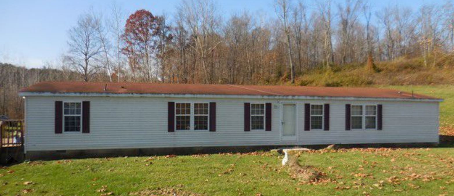
Subject Property is a 3 BR / 2 BA Single Family Home containing 2,016 Sq Ft +/- built in 2001. Minimum bid $ 33,333.33. All auctions end Wednesday's at 1pm. 5% buyers premium will apply over and above high bid. Please read terms and conditions for details related to purchasing foreclosure property. Interior showings are not available. Buyer agents must register with Auctioneer to earn commission at https://www.gryphonusa.com/broker-acknowledgement-form/ *** Information available has come from public sources and is believed to be accurate but is not guaranteed. Buyers should conduct their own due diligence before bidding. Auctioneer/PSO has not physically viewed the property.
Legal Description
Tract Seven: Situate in the Township of Colerain, County of Ross, State of Ohio, being part of the 131.933 acre tract conveyed to Ken W. and Alma M. Roark (o.r. Vol. 75 page 358 Ross County deed records), bounded and described as follows: Beginning for reference at a Mag-nail found in the center of Walnut Creek Road (county road no. 233) at the southeast corner of the 1.253 acre tract conveyed to David W. Stevens (OR Vol. 125 Page 927); Thence along the center of Walnut Creek road. S. 08 deg. 01' 59" W. 41.01 ft. to a railroad spike found at the northernmost corner of the 1.885 acre tract conveyed to Joann Hedrick (OR Vol. 80 Page 133); Thence with the northwest and west lines of Hedrick's tract the following (2) courses, 1.S. 27 deg. 35' 59" W., passing an iron pin found at 45.45 ft., a total distance of 489.10 ft. to an iron pin set and 2.S. 15 deg. 09' 36" W. 254.27 ft. to an iron pin found at the northwest corner of the 0.477 acre tract conveyed to Joann Hedrick (o.r. vol. 141 page 2083); Thence with the west line of Hedrick's tract, S. 08 deg. 03' 47" W. 68.49 ft. to an iron pin set and being the actual point of beginning of the tract herein described; Thence continuing with the West line of Hedrick's tract and with the west line of the 1.000 acre tract conveyed to Robert D. Butcher (o.r. vol. 141 page 2086) and with the west line of the 3.051 acre tract conveyed to Perk L. and Cathy J. Persinger (o.r. vol. 141 page 637) the following (3) courses, 1.S. 08 deg. 03' 47" W. 457.57 ft. to an iron pin found, passing iron pins found at 37.43' and 264.08', 2.S. 21 deg. 26' 21" E. 261.37 ft. to an iron pin found and 3.S. 00 deg. 08' 22" E. 347.70 ft. to an iron pin found at the southeast corner of the tract of which this is a part and also being in the north line of the 12.8236 acre tract conveyed to Mark S. and Dauphne A. Boley (o.r. vol. 141 page 2247); Thence with the south line of the tract of which this is a part and with the north line of Boley's tract, N. 83 deg. 00' 33" W. 1273.39 ft. to an iron pin found at the northeast corner of the 20 acre tract conveyed to Robert R. Thornton o.r. (vol. 18 page 584); thence with the north line of Thornton's tract, N. 81 deg. 46' 00" W. 935.20 ft. to an iron pin set; Thence with new lines through the tract of which this is a part the following (7) courses, 1.N. 16 deg. 50' 24" E. 1151.72 ft. to an iron pin set, 2.S. 65 deg. 01' 07' E. 320.91 ft. to an iron pin set, 3.S. 48 deg 34' 23' E. 1030.84 t. ft. to an iron pin set, 4.N. 51 deg. 49' 33' E. 197.35 ft. to an iron pin set, 5.N. 51 deg. 57' 40" E. 281.34 ft. to an iron pin set, 6.N. 12 deg. 50' 15' E. 255.81 ft. to an iron pin set, 7.S. 77 deg. 09' 45' E. 334.60 ft. to the actual point of beginning, containing 40.000 acres. subject to all easements and rights-of-way of record pertinent to this tract. Conveyed herein to these grantees, their heirs and assigns forever is a right-of-way easement for the purpose of ingress and egress and for the purpose of installing and maintaining public utility lines from walnut creek road to the above described 40.000 acre tract, said right-of-way easement being further described as follows: Beginning at a mag-nail found in the center of Walnut Creek road (county road no. 233) at the southeast corner of the 1.253 acre tract conveyed to David W. Stevens (o.r. vol. 125 page 927); Thence along the center of walnut creek road, S. 08 deg. 01" 59" W. 41.01 ft. to a railroad spike found at the northernmost corner of the 1.885 acre tract conveyed to Joann Hedrick (o.r. vol. 80 page 133): Thence with the northwest line of Hedrick's tract, passing an iron pin found at 45.45 ft. and an iron pin set at 168.73 ft. S. 27 deg. 35' 59" W. a total distance of 489.10 ft. to an iron pin found; Thence with another line of Hedrick's tract. S. 15 deg. 09' 36" W. 254.27 ft. to an iron pin found; Thence with the west line of the 0.477 acre tract conveyed to Hedrick, S. 08 deg. 03' 47" W. 68.49 ft. to an iron pin set, said iron pin being the northeast corner of the above described 40.000 acre tract; Thence with the north line of said tract, N. 77 deg. 09' 45" W. 50.17 ft. to a point; Thence with lines through the adjacent 5.000 acre and 2.057 acre tracts the following (4) courses, 1.N. 08 deg. 03' 47" E. 67.41 ft. to a point, 2.N. 15 deg. 09' 36" E. 262.82 ft. to a point, 3.N. 27 deg. 35" 59" E. 396.34 ft. to a point and 4.N. 08 deg. 01' 59" E. 116.79 ft. to a point in the south line of Stevens tract; Thence with the South line of Stevens' tract, passing an iron pin found at 50.00 ft., S. 81 deg. 57' 56" E. a total distance of 80.00 ft. to the point of beginning and being the herein conveyed easement in its entirety. Being 19.208 acres of the northeast quarter of section 31 and 20.792 acres of the northwest quarter of section 32, township 10 north, range 20 west. This legal description is based on field surveys performed May 13, 1997, May 29, 1998, March 04, 1999 and August 07, 2000 under the direction and supervision of Michael T. Slagle, Ohio professional surveyor no. 6699. The magnetic bearings in this legal description are based on the lines of the tract of which this is a part and are used solely for the purpose of denoting angles. All iron pins set by this surveyor are 5/8 inch diameter, 30 inches long with an identification cap labeled Slagle S-6699, unless otherwise indicated. Being part of Engineer's Parcel No. 2-9-55.
Location
Foreclosure Details
Click the link to review the Conditions of Sale for this auction.
Conditions of SaleAuction By
